Nam Ou Dams Hydropower Info by Hobo Maps - Go to Hydropower Web Page - - Home
Click HERE to view a gallery of full-size photos for Nam Ou dams 1 thru 7, mostly aerial views.
This web page is a concise summary of all 7 projects - click to see detailed and separate web pages for each project - Nam Ou 1, Nam Ou 2, Nam Ou 3, Nam Ou 4, Nam Ou 5, Nam Ou 6 & Nam Ou 7.
The Nam Ou cascade hydropower project is a series of seven hydroelectric dams along the Nam Ou (river) in Phongsaly and Luang Prabang provinces of northern Lao PDR. The project is managed by Power Construction Corporation of China (PowerChina) and the Lao government.
Construction of the hydropower project was completed in two phases. Phase One dams Nam Ou 2, 5 & 6 began operating in May 2016. Phase Two was completed in 2020 for Nam Ou 1, 3, 4 and 7 dams.
The feasibility study report for Phase Two Dam Projects 1, 3, 4 & 7 was approved by the Lao Government in February, 2014. The EIA report was approved by the Lao Government in October, 2014. In August, 2014, the first draft of the PPA Agreement was submitted to EDL. We are not sure if or when final PPAs were executed for these four projects.
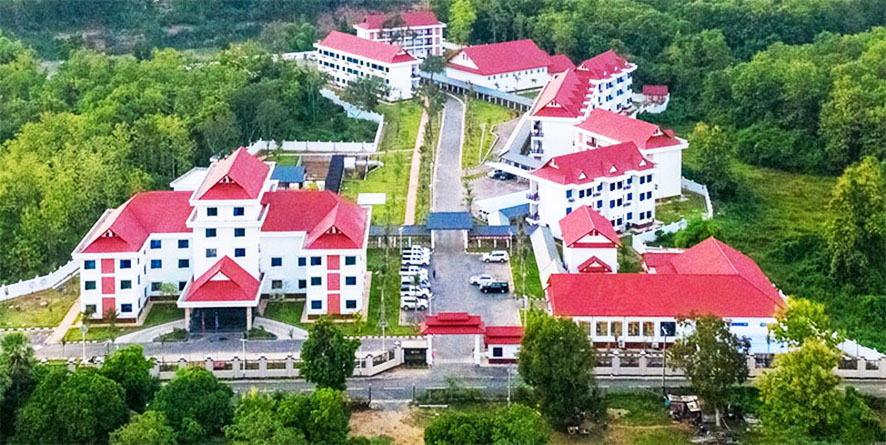
Image below of Nam Ou Power Co. Ltd. facility in Luang Prabang.

The projects were developed as a joint venture Nam Ou River Basin Hydropower Company Ltd. with EDL owning (20%) and Sinohydro (80%), a subsidiary of Power China Resources LTD. The projects operate under a build, operate and transfer (BOT) agreement signed April 2011. Estimated investment in the 7 projects was US $2.73 billion. EDL ownership shares may have been transferred to EDL GEN.
Later info from EDL-GEN website in November 2021 has the ownership structure as Power China Resources Limited owning 85% and EDL-GEN 15% for Nam Ou 2, 5 & 6.
Nam Ou 1, 3, 4 and 7 Phase 2 hydropower projects reportedly have franchise periods of 29 years. The Phase 2 projects apparently have different financing and ownership structures than Phase 1 projects that aren't entirely clear from public info available on the web ( maybe with 25 year franchise periods).
China Development Bank was a major financer in all seven projects.
The generating capacity of all seven dams is 1,272 megawatts with average annual generation capacity of 5,046 GWh.
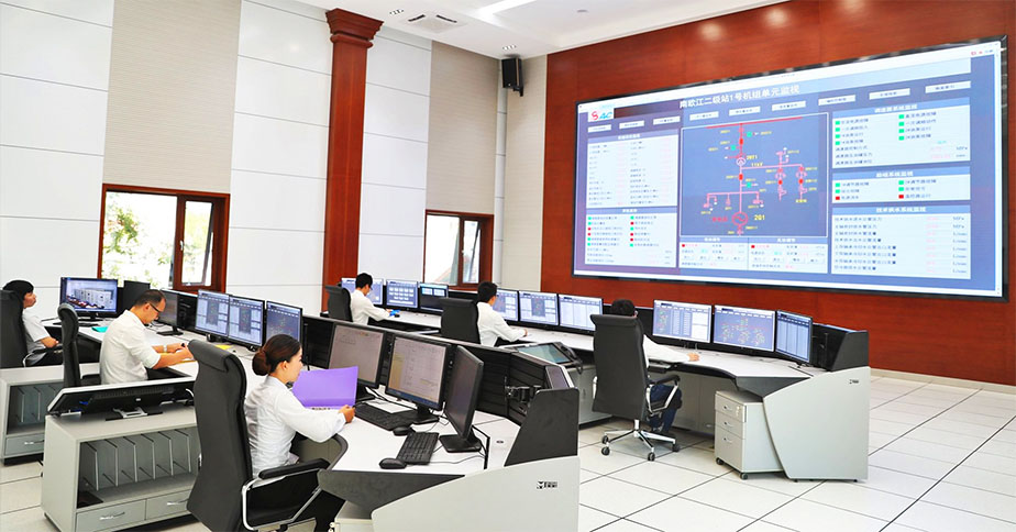
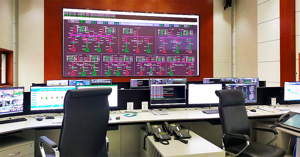
Nam Ou Central Control Room image below - big screen displays all 7 power plants real time activity.
The Nam Ou cascade dams were developed in part to provide power for Northern Laos and other projects in the region including segments of the Lao-China Railway project.
Since the 1,270 MW output capacity is more than needed for Laos, an agreement was reached in August 2021 pursuant to a Memorandum of Understanding to export 840 MW of the output to Electricity Vietnam (EVN). However in Feb. 2023 it was announced that power produced by Nam Ou 5 would not be included in a planned sale to Vietnam.
The Nam Ou river flows 450 km south from mountains near the Lao-China border to join the Mekong River just north of Luang Prabang town. The river goes through the provinces of Phongsaly, Oudomxay and Luang Prabang. If all 7 reservoirs are full at the same time they would occupy about 350 km length of that 450 km and the Nam Ou would be completely pacified and just a series of reservoirs.
Nam Ou 7 is the only one of the seven Nam Ou dams to have significant annual regulation capability. Nam Ou 5 has some seasonal regulation capability.
The Nam Ou Cascade is the only hydropower project in Laos that harnesses an entire river basin with coordinated projects designed, constructed and managed by the same entity. The seven cascades development scheme replaced the previous high dam with large reservoir proposal.
A good video for the project with Chinese language audio and English subtitles can be seen HERE .
EACH DAM'S LOCATION AND MAIN FEATURES BELOW:
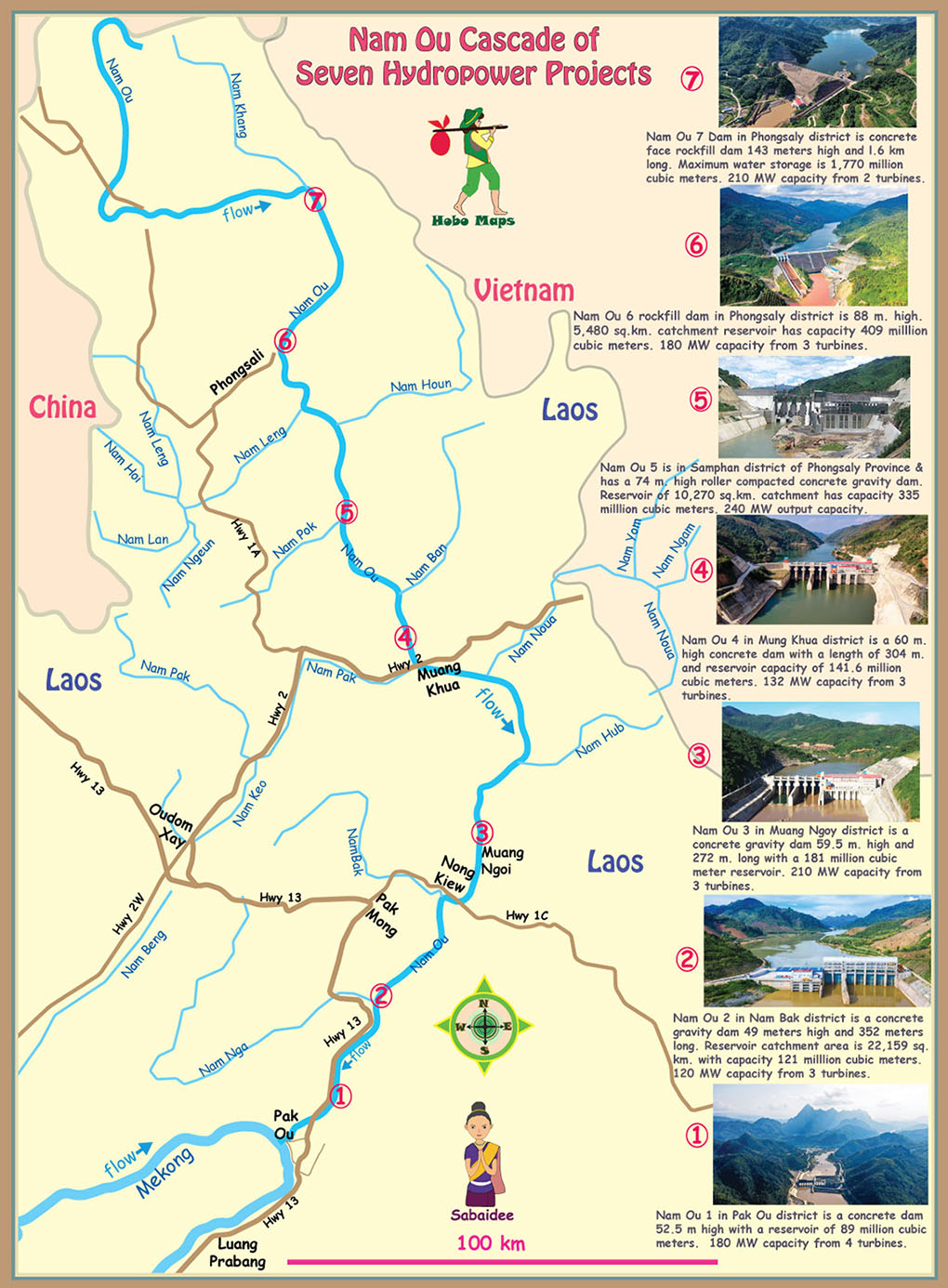
Nam Ou 1 Hydropower Project (HPP) is located in Pak Ou district of Luang Prabang Province not too far from where the Nam Ou river joins the Mekong. The concrete dam has a height of 52.5 meters. It stores water 307 meters above sea level in a reservoir with capacity of 89 million cubic meters. 180 MW capacity from 4 turbines. Dam site coordinates - 20°08'57.8"N 102°19'02.8"E (20.149384, 102.317435).
Nam Ou 2 HPP is situated in Nam Bak district of Luang Prabang Province and has a concrete gravity dam with a low-head gated barrage power station. The reservoir has a catchment area of 22,159 square kilometers. Dam is 49 meters high and 352 meters long. Reservoir capacity is 121 milllion cubic meters. 120 MW capacity from 3 turbines. Dam site coordinates - 20°23'13.2"N 102°27'03.6"E (20.387, 102.451).
Nam Ou 3 HPP located in Muang Ngoy district is a concrete gravity dam with height of 59.5 meters and crest length of 272 meters. The reservoir has 181 million cubic meters of reservoir capacity stored 360 meters above sea level. 210 MW capacity from 3 turbines. Dam site coordinates - 20°49'15.1"N 102°39'59.7"E (20.820849, 102.666590).
Nam Ou 4 HPP situated in Mung Khua district is a concrete dam having a crest length of 304.5 meters and an elevation of 60.25 meters above sea level. The reservoir’s capacity when the surface is at 386 meters above sea level is 141.6 million cubic meters. 132 MW capacity from 3 turbines. Dam site coordinates - 21°06'14.4"N 102°29'52.8"E (21.104, 102.498).
Nam Ou 5 HPP, located in Samphan district of Phongsaly Province has a roller compacted concrete gravity dam 74 meters high and 335 meters long with a reservoir catchment area of 10,270 square kilometers. Reservoir capacity is 335 milllion cubic meters. 240 MW output capacity. Dam site coordinates - 21°24'39.6"N 102°20'38.4"E (21.411, 102.344).
Nam Ou 6 HPP has its base in Phongsaly district of Phongsaly Province and has a rockfill dam 88 meters high and 409 meters long with a reservoir catchment area of 5,480 square kilometers. Reservoir capacity is 409 milllion cubic meters. 180 MW capacity from 3 turbines. Dam site coordinates - 21°46'08.4"N 102°11'42.0"E (21.769, 102.195).
Nam Ou 7 HPP in Phongsaly district of Phongsaly Province is a concrete face rockfill dam with an elevation of 143.5 meters and crest length of 591 meters. The normal water storage will be 635 meters above sea level with storage volume of 1,770 million cubic meters. 210 MW capacity from 2 turbines. Dam site coordinates - 22°05'16.8"N 102°15'28.8"E (22.088 102.258).
For the seven cascades of the Nam Ou HPP, different types of dam were adopted due to different terrain, geological, scale and flood discharge conditions. The dam type for 1, 2 & 4 projects is Gate Dam. Dams 3 & 5 are concrete gravity dams. Composite Geomembrane Faced Soft-rock-fill Dam is used in the sixth dam. Dam 7 is a Concrete Faced Rock-fill Dam. Different types of dams require different materials, structures, stress distributions, flood discharge modes and construction methods.
Raw materials for construction such as sand and aggregates were sourced from areas close to each dam and have different characteristics. Each situation required unique testing, processing and mixing.
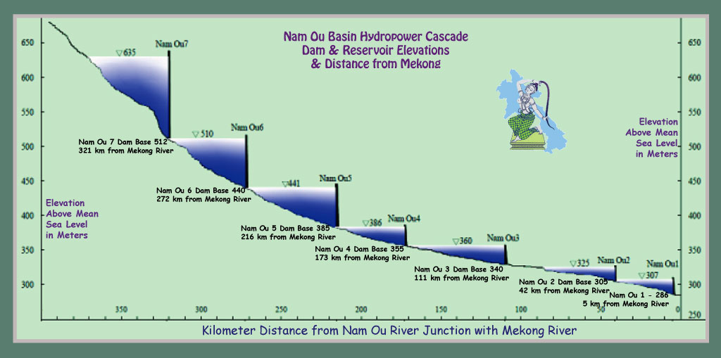
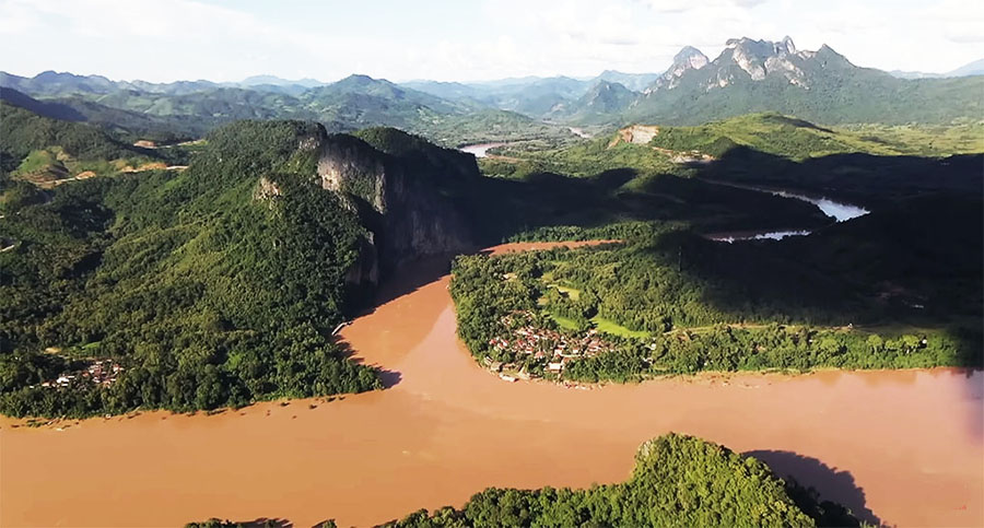
Image below of Nam Ou river joining the Mekong at Pak Ou cliffs
Lao Power Grid Black Start Info - See our separate web page Black Restart for info on how the Nam Ou hydropower project has been designated as the Black Start primary system in Laos to restart and recharge the electric power grid when the system crashes and goes out. Nam Ou Dam 3's power plant would be the first to regenerate using a diesel generator to get its system activated and then successive nearby systems will be restarted until the entire grid is back online.
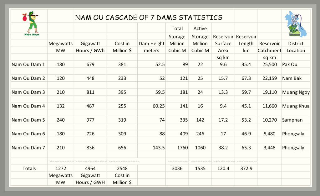
Nam Ou Dams statistics chart below:

Location of all 7 dams in Nam Ou Cascade shown in map below with small-scale images:
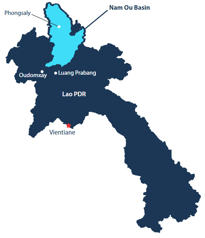
Nam Ou watershed drainage basin is light blue area in Laos map below.
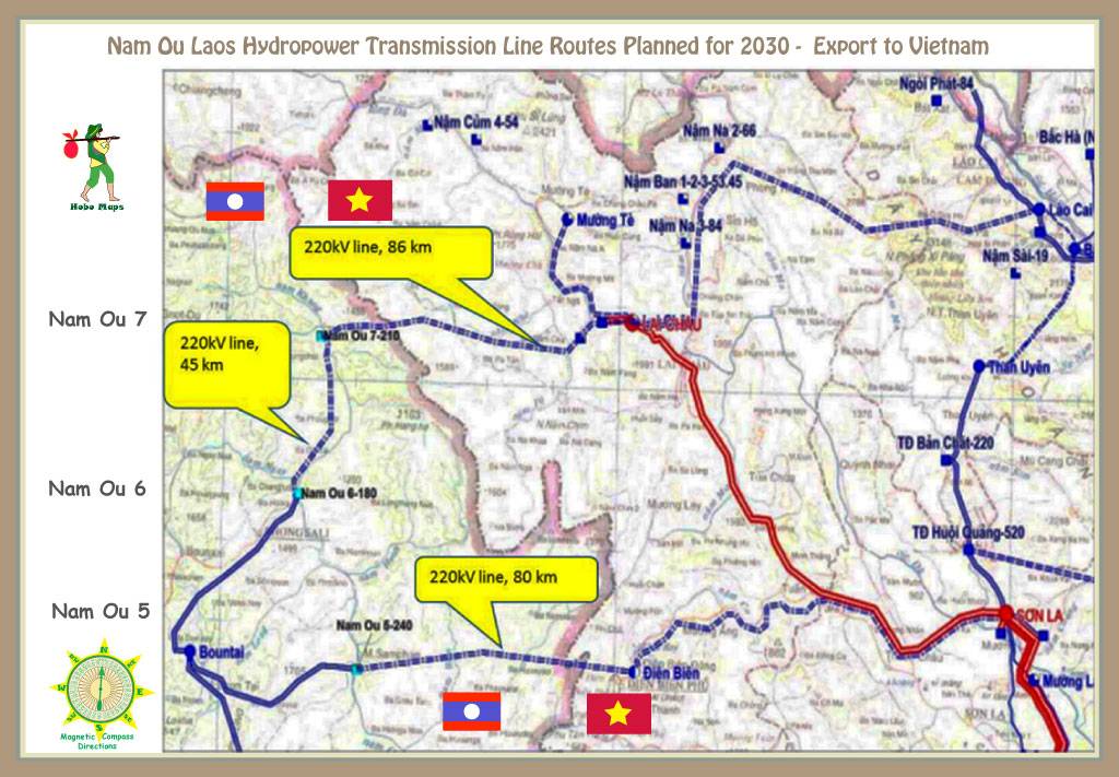
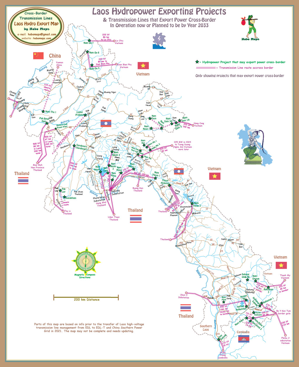
Nam Ou Dams 5, 6 & 7 have been studied for export of their output (or part of it) to Vietnam as seen in 2030 planning maps below. In 2025 it seems that export of output to Vietnam is not likely in the near future due to lack of transmission lines.
For all 7 Nam Ou projects, 23 new villages for immigrants were built with over 2,300 families and a population of over 12,600 relocated. More than 500 kilometers of roads were built or expanded and more than 20 bridges were built, as well as docks, schools, markets, hospitals and temples.